Understanding Its Place in the Canary Islands and Europe
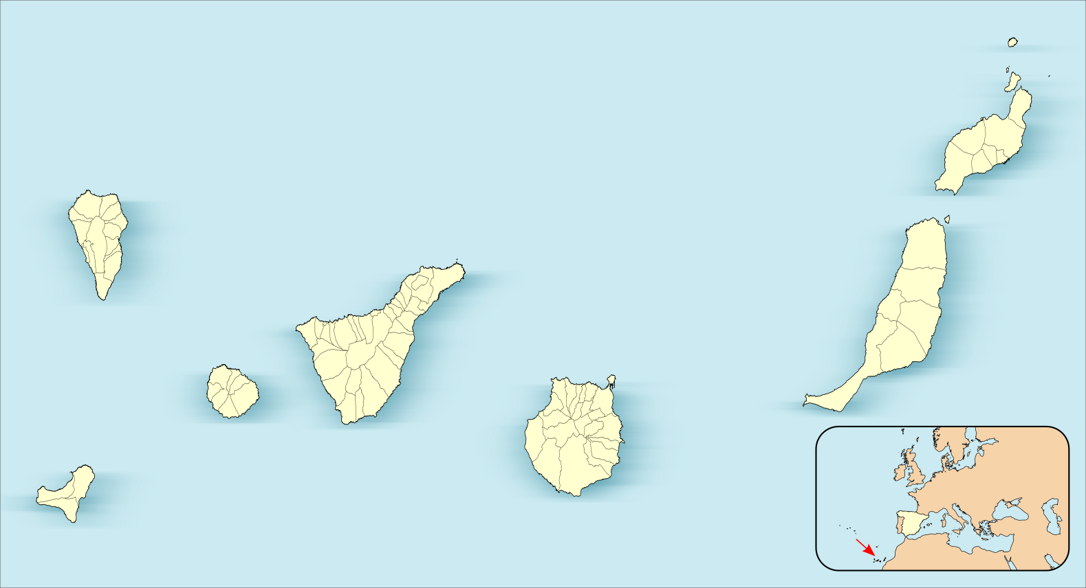
This location map clearly illustrates Tenerife’s position as part of the Canary Islands, an archipelago of Spain situated in the Atlantic Ocean. Tenerife is depicted prominently, centered among the group of islands that make up the archipelago, highlighting its status as the largest of the Canary Islands.
Location Map
Tenerife’s Position
- Tenerife is situated in the central-western part of the Canary Islands. It lies to the west of Gran Canaria and the northeast of La Gomera. The map shows Tenerife’s extensive road network and administrative divisions, indicating it as a hub of activity within the island group.
- Relative to Europe: The inset at the bottom right of the map situates the Canary Islands off the northwest coast of Africa and to the southwest of the Iberian Peninsula, where mainland Spain and Portugal are located. A red arrow points to the archipelago’s location in the broader context of Europe, emphasizing its geographical separation from the continent.
Tenerife’s central position within the Canary Islands is a geographical statement and reflects its pivotal role in the region. As the most populous and largest of the islands, Tenerife serves as a focal point for commerce, culture, and tourism within the archipelago. The detailed road network illustrated on the map underlines the island’s modern infrastructure, connecting the rugged coastline with the mountainous interior and facilitating access to various natural wonders, urban centers, and ports that stimulate Tenerife’s economy and culture. The administrative divisions marked on the map correspond to the island’s municipalities, each with unique local governance, contributing to Tenerife’s rich tapestry of communities.
As depicted in the inset map, Tenerife’s location speaks to its strategic and historical significance concerning Europe. The Canary Islands’ position, lying off the northwest coast of Africa, places them closer to the equator than mainland Europe, endowing the archipelago with a subtropical climate that contrasts with the temperate zones of the continent. This geographical placement has historically made the islands a crucial stopover for maritime exploration and trade between Europe, Africa, and the Americas (North America & South America). The red arrow not only points out the physical location of the Canary Islands but also symbolically highlights their role as a bridge between continents and cultures, a crossroads of the Atlantic that has shaped the history and development of Tenerife and its neighboring islands.
Neighboring Islands:
- Gran Canaria: To the east of Tenerife, Gran Canaria is another major archipelago island known for its diverse landscapes and urban centers, such as Las Palmas de Gran Canaria.
- La Gomera: Southwest of Tenerife, the smaller island of La Gomera is visible. It is renowned for its lush laurel forests and the UNESCO World Heritage Site of Garajonay National Park.
- La Palma and El Hierro: To the northwest and southwest, respectively, La Palma and El Hierro are smaller yet significant islands of the archipelago, each with unique geographical and cultural attributes.
Gran Canaria
Gran Canaria, situated to the east of Tenerife, stands as a significant island within the Canary Islands, renowned for its variety of microclimates and landscapes that range from the white sandy beaches of the south to the green and rugged mountains of the interior. Las Palmas de Gran Canaria, the capital city, is a bustling urban center that combines historic neighborhoods with modern amenities, reflecting the island’s blend of tradition and contemporary lifestyle. The city is also an important cultural hub, hosting numerous festivals and events celebrating the island’s rich heritage and contemporary art scene. Gran Canaria’s diverse environment supports many outdoor activities, from hiking in the central mountain ranges to watersports along its extensive coastline.
La Gomera
La Gomera, to the southwest of Tenerife, may be smaller in size but is no less impressive with its striking natural beauty. The island is most famous for its ancient laurel forests, which cloak the central highlands in a verdant shroud. These forests are part of Garajonay National Park, a UNESCO World Heritage Site that preserves an ecosystem that once covered much of southern Europe. La Gomera is also known for its unique whistling language, Silbo Gomero, which the inhabitants use to communicate across the deep valleys and gorges that characterize the island’s topography. The island’s traditional ways of life, including pottery and weaving, continue to thrive, offering visitors a glimpse into the Canary Islands’ enduring cultural practices.
La Palma
La Palma, to the northwest, is often referred to as ‘La Isla Bonita’ or ‘The Beautiful Island’ due to its stunning natural landscapes, which include the Caldera de Taburiente National Park with its immense crater, extensive pine forests, and a network of hiking trails that traverse diverse terrains. La Palma is also recognized for its clear skies and is home to one of the world’s leading astrophysical observatories.
El Hierro
El Hierro, the smallest and furthest south and west of the islands, is noted for its rugged coastline, rich marine life, and commitment to sustainability. It was the first island in the world to become self-sufficient in energy, relying entirely on renewable sources. El Hierro’s cultural life is deeply connected to the natural environment, with local festivals and crafts celebrating the island’s geological and maritime heritage. These islands form a constellation of unique cultural and natural wonders, each contributing to the rich mosaic that defines the Canary Islands.
Conclusion
This map serves as an informative tool for understanding Tenerife’s geographical context within the Canary Islands and its location concerning the European continent. It underscores the island’s strategic position and role as a central point within this Atlantic archipelago.